Charts
Stylised early-18th-century charts. They are approximate views, not surveys.
Bahamas & Florida Straits
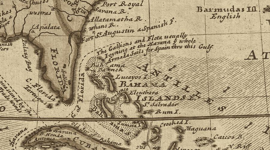
| Chart feature | Reference |
|---|---|
| New Providence | Nassau’s island and harbour. |
| Andros | Forests, creeks and mangroves west of New Providence. |
| Eleuthera and Harbour Island | Settled islands east of New Providence. |
| Crooked Island Passage | Southern Bahamian route through the cays. |
| Bahama Banks | Pale shallows and treacherous reef water. |
| Florida and the Keys | Wreck coast and the approaches to the Straits. |
| Florida Straits | Treasure-fleet route between Florida and Cuba. |
| Havana | Spanish port, fleet centre and base for guarda costas. |
| Windward Passage | Channel between Cuba and Saint-Domingue, southeast of the Bahamas. |
| Devil’s Teeth | Reef south of the upper Florida Keys; placement is approximate. |
New Providence & Nassau Harbour
North is at the top; coastlines and small cays are not to scale.
| Chart feature | Reference |
|---|---|
| Cluster of houses on the north shore | Nassau town: waterfront, warehouses, taverns, market and landing. |
| Square bastioned fort west of town | Fort Nassau, with old walls and few serviceable guns. |
| Long island across the harbour mouth | Hog Island, sheltering the anchorage and leaving two channels. |
| Water between town and Hog Island | Nassau Harbour and the roadstead. |
| Shelving beach on Hog Island’s inner shore | The Careening Beach, suitable for heaving down vessels. |
| Grey-blue inland lagoons | New Providence salt ponds. |
| Tiny tree marks | Scrub woods. |
| Crosses and stippling offshore | Reefs, shoals and the Bahama Banks. |
| Western shore | A secluded cove and rocky coast; exact placement is approximate. |
| Inland rise and eastern slopes | Ground suited to storehouses, terraces and irrigation. |